
![]()
The main purpose of waterquality is to quickly and
easily convert satellite-based reflectance imagery into one or many
well-known water quality indices designed for the detection of Harmful
Algal Blooms (HABs) using the following pigment proxies: chlorophyll-a,
blue-green algae (phycocyanin), and turbidity. Currently, this package
is able to process 40
algorithms for the following satellite-based imagers: WorldView-2,
Sentinel-2, Landsat-8, MODIS, MERIS, and OLCI. In order to improve the
aesthetics of the wq_calc() output, a series of
Map_WQ() functions were developed to help reduce technical
barriers and simplify the complexities in selecting a map layout.
Additional functionality of the package includes a series of
extract_lm() functions that wrap the “Fitting
Linear Models” and “caret” packages to
quickly generate crossvalidated linear models and standardized outputs
(r2, p-value, slope, intercept of the global lm model &
average r2, average RMSE, average MAE of crossvalidated
model) for any number of algorithm and water quality parameter
combinations. It is important to note that the extract_lm()
functions require ground-truth data in order to develop the models. For
a more detailed look into the full functionality of
waterquality, please view “Introduction
to the waterquality package”. For a broader look into how to apply
this tool into a research workflow or for more information on topics
such as data acquisition, image pre-processing, or results, see our
publication entitled “Waterquality:
An Open-Source R Package for the Detection and Quantification of
Cyanobacterial Harmful Algal Blooms and Water Quality”.
Additionally, we have recently developed and published a complementary python-based version of waterquality compatible with ESRI ArcGIS and ArcPro. For more information please visit “waterquality for ArcGIS Pro Toolbox”
You can install the released version from CRAN with:
install.packages("waterquality")You can install waterquality from github with:
# install.packages("devtools")
devtools::install_github("RAJohansen/waterquality")The main function in this package is wq_calc():
library(waterquality)
library(raster)
s2 = stack(system.file("raster/S2_Harsha.tif", package = "waterquality"))
s2_two_alg = wq_calc(s2, alg = c("MM12NDCI", "Al10SABI"), sat = "sentinel2")plot(s2_two_alg)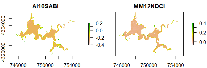
We encourage users to submit issues and enhancement requests so we may continue to improve our package.
Furthermore, if you have a water quality algorithm that was not on our list, and you would like for it to be included in our package please email Richard.A.Johansen@erdc.dren.mil.